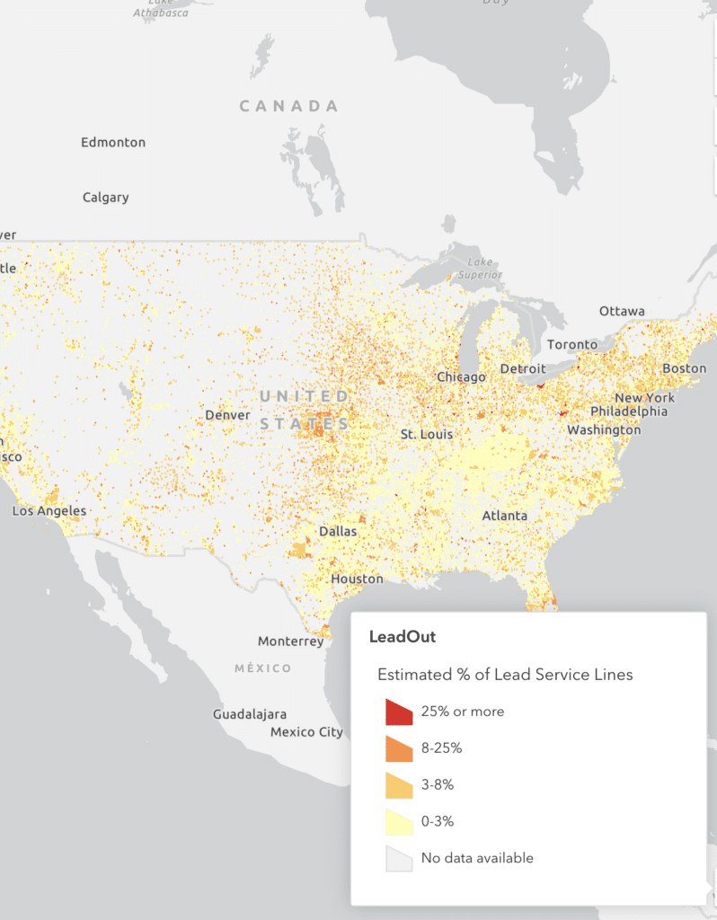
Nationwide Map
There are millions of lead pipes in our drinking water system, potentially endangering vulnerable people in their homes.
A challenge for planning, budgeting, and implementing our nationwide, state-level, and local response to this problem is the lack of visibility into the locations of these lead pipes or lead service lines.
LeadOut is a collaboration between BlueConduit and Google.org to illuminate and help resolve this problem. Look for it in 2023!
BlueConduit originated the method for statistically predicting service line materials. Our team started in 2016 in Flint, Michigan, and our data science/machine learning predictions have been honed in over one hundred communities in the United States and in Canada. In August 2022, the EPA included our work in its Lead and Copper Rule Revision Inventory Guidance (see EPA Service Line Inventory Guidance includes Machine Learning Recommendations).
We have now applied our approach nationwide.
For the predictions, we use data available in the public record, including but not limited to:
- Counts of service lines of each material for water systems submitted to state regulators
- Service line inventories from lead service line maps and datasets that are published online by water systems
- SDWIS and DWINA data
- U.S. Census and American Community Survey
For the map boundaries, we use the dataset of U.S. water system boundaries prepared by the collaboration of the Environmental Policy Innovation Center (EPIC), the Internet of Water Coalition, SimpleLab, and many other partners.
In 2023, these predictions will be available in an interactive map. We are reviewing our predictions and our presentation at this time, so please stay tuned. If you want to be notified when it is available, subscribe now.
Let me know when the map is live!
What You Can Do Now
If you know your water system’s ID (available via this EPA search tool), you can find out our estimate right now via our Lead Service Line Estimate Look Up Form.
Support for this Project
Both Google.org and the Rockefeller Foundation have provided BlueConduit funding, through the BlueConduit Charitable Fund, to create and showcase predictions in the form of an interactive map. Here is more information about their support:
-
Progress in Toledo and Buffalo powered by Lead Service Line Maps
-
The Rockefeller Foundation commitment helps scale LSL inventory and removal nationwide
-
BlueConduit launches new software to locate and replace lead service lines
-
Google Grant Advances BlueConduit’s Mission to Identify and Remove Lead Service Lines
-
BlueConduit and Google.org Announce Coalition to Help Communities Quantify and Locate Dangerous Lead
-
BlueConduit and The Rockefeller Foundation partner
About BlueConduit
BlueConduit originated the approach of using machine learning to predict lead pipes and have been doing it longer than anyone else.
Our team has been helping local officials and their engineering partners identify and remove lead service lines since 2016.
We’ve now created our software platform to streamline this process for our utility and engineering partners.